Our Ocean at Work: A Thoroughly Modern Tool for Ancient Mariners
Published by Ocean Conservancy
Flares of bright green with yellow streaks and intense spots of red and orange lights up a map of blue stretching out from the eastern shore.
This data visualization captures one of the most ancient ways our species has traversed the planet—on ships that carry us across oceans to distant shores.
Each line on the map traces the unique informational “fingerprint” that is a ship’s Automatic Identification System. Since 2002, the U.S. Coast Guard has been using this tracking system to maintain the safety and security for vessels of all kinds in American waters. Today, the AIS system receives over 92 million messages per day from more than 12,700 vessels along America’s coasts and Exclusive Economic Zone. Over the time that this vast volume of data has been collected, it has been recognized as a treasure trove to federal agencies and other ocean users—if it could be integrated into the data portals and other tools that fuel ocean management decisions in the Northeast and Mid-Atlantic regions.
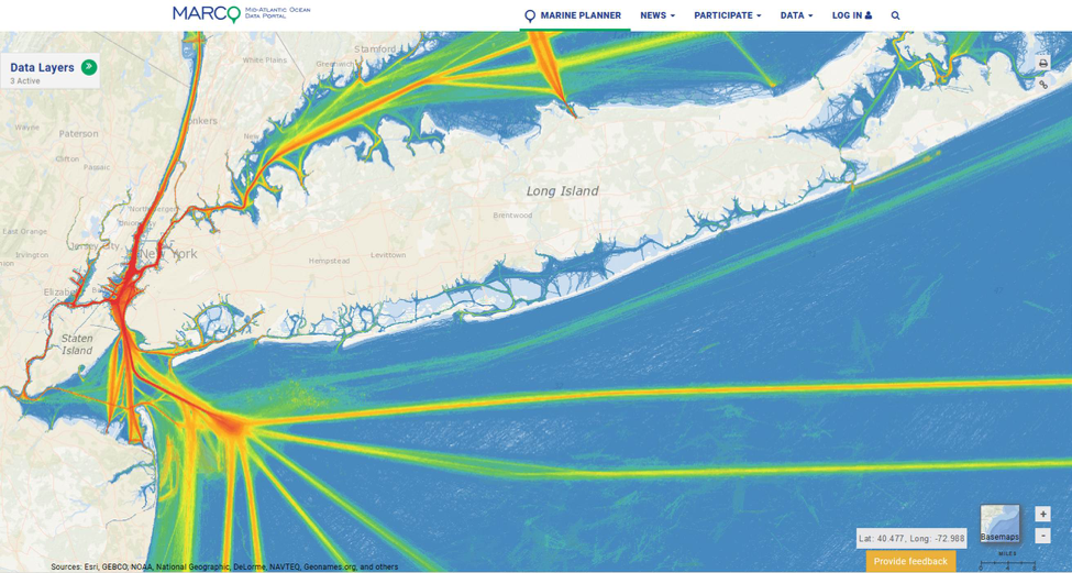
Thanks to a joint effort with NOAA’s Office for Coastal Management and the Marine Cadastre team, the Coast Guard tracking data is now publicly available on both the Northeast and Mid-Atlantic Data Portals. These data portals are a powerful tool allowing for layer upon layer of other data sources to be combined with the Coast Guard data, like wind energy development and the migratory routes of iconic marine wildlife like whales, allowing us to better visualize and anticipate potential conflicts. What emerges is a complex, comprehensive snapshot of ocean uses. Today, the AIS data layer is one of the most-used layers in both the Northeast and Mid-Atlantic Data Portals.
Shared data is one of the foundations of successful ocean planning.
Together with innovative management tools and open engagement, it allows diverse ocean users to recognize areas that could spark conflict. Ocean planning allows people across business, industry and conservation to navigate a complex set of parameters to achieve better results.
By having AIS data readily available on the Northeast and Mid-Atlantic Data Portals, agencies like the Coast Guard can work with Bureau of Ocean Energy Management and NOAA to avoid potential conflict areas between high-traffic shipping routes and proposed offshore wind development or marine mammals migratory routes.
The AIS data provided by the U.S. Coast Guard and the ability to visualize this data for working with other state and federal agencies demonstrates how ocean planning works. It is just one example of how this cooperative, common-sense approach can balance maritime safety and navigation risks while America’s ocean economy surges ahead.

The post Our Ocean at Work: A Thoroughly Modern Tool for Ancient Mariners appeared first on Ocean Conservancy.
Read the full article at: https://oceanconservancy.org/blog/2017/12/04/ocean-work-thoroughly-modern-tool-ancient-mariners/